![]()
On August 24, 2016, at 03:36 (local time) a ML 6.0 earthquake (Mw 6.0) struck the Central Apennines between the towns of Norcia and Amatrice. This earthquake occurred in a sector of the Apennines characterized by high geodetic strain-rates (e.g., D’Agostino 2014) and where several continuous GNSS networks are operating.
INGV routinely collect and analyze the raw data using different software and approaches. In particular, GPS data are analyzed by the INGV National Earthquake Center (CNT) using the GIPSY-OASIS, GAMIT/GLOBK and BERNESE software (e.g., Avallone et al., 2010). Following the procedures described in Devoti (2012), and adopted for the 2012 Emilia (northern Italy) sequence (Serpelloni et al., 2012), here we provide the co-seismic displacements field obtained from the analysis of pre- and post- August, 24 mainshock positions obtained from the analysis of continuous GPS stations, using three days (up to day of year 2016/239) after the mainshock to estimate the co-seismic offsets.
The final co-seismic displacement field can be considered as a “consensus” measurement and is the result of a comparison and validation process with repeated feedback between the three different analysis centers. The comparison is done with the intention of comparing the different results and reducing sources of error associated with individual processing strategies, to allow the final combination of the different displacement fields into a single “consensus solution”. The process assesses the robustness of each single GPS result, thus minimizing erroneous interpretations of individual solutions.
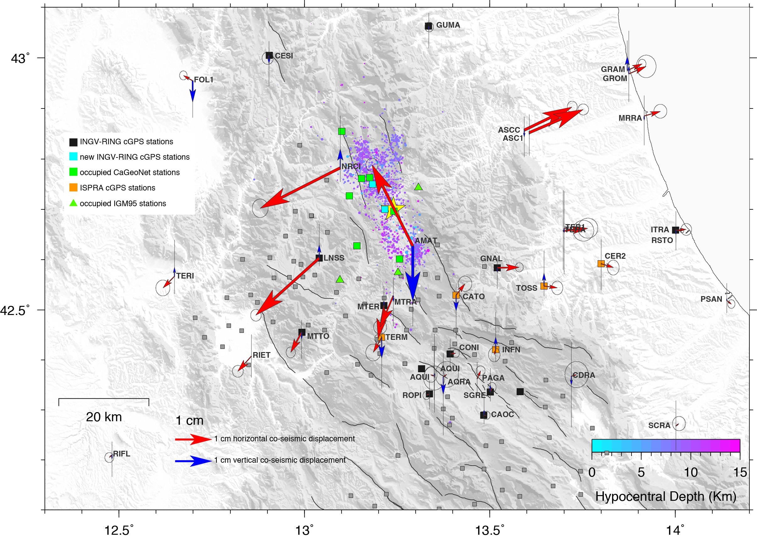
The figure shows the horizontal (red arrows) and vertical (blue arrows) consensus co-seismic displacements (with 68% confidence errors), together with the August, 24 M6 mainshock (yellow star) and aftershocks (colored as a function of depth) from http://iside.rm.ingv.it. The black squares show the position of the INGV-RING stations (http://ring.gm.ingv.it). The grey squares show the position of the CaGeoNet network (Anzidei et al. 2008; Galvani et al., 2012) stations, where the green squares indicate benchmarks that have been re-occupied a few hours after the August, 24 mainshock. The green triangles indicate the position of IGM95 benchmarks (http://www.igmi.org/geodetica/) that have been occupied by ISPRA (www.isprambiente.gov.it) after the mainshock. The orange squares indicate continuous GPS stations managed by ISPRA and the Civil Protection Department (DPC).
Other continuous GPS data have been obtained from the Regione Abruzzo GNSS network (http://gnssnet.regione.abruzzo.it), the Regione Lazio GNSS network (http://gnss-regionelazio.dyndns.org), the ItalPos GNSS network (http://it.smartnet-eu.com), the NetGeo GNSS network (http://www.netgeo.it), the Regione Umbria GNSS network (http://www.umbriageo.regione.umbria.it), the ASI-Geodaf network (http://geodaf.mt.asi.it) and the Euref network (http://www.epncb.oma.be).
The co-seismic displacements can be downloaded as ASCII file at the following link, and cited https://ingvterremoti.files.wordpress.com/2016/08/20160829_rapportopreliminare_finale.pdf
References
Anzidei et al, (2008). La rete geodetica GPS dell’Appennino centrale CA-GeoNet. Quaderni di Geofisica, 54; http://istituto.ingv.it/l-ingv/produzione-scientifica/quaderni-di-geofisica/numeri-pubblicati-2008.
Avallone, A. et al. (2010), The RING network: improvements to a GPS velocity field in the central Mediterranean, Annals of Geophysics, 53(2), 39–54, doi:10.4401/ag-4549.
D’Agostino, N. (2014), Complete seismic release of tectonic strain and earthquake recurrence in the Apennines (Italy), Geophys. Res. Lett., doi:10.1002/(ISSN)1944-8007.
Devoti, R. (2012). Combination of coseismic displacement fields: a geodetic perspective, Annals of Geophysics, 55 (4); doi:10.4401/ag-6119.
Galvani, A., M. Anzidei, R. Devoti, A. Esposito, G. Pietrantonio, A. R. Pisani, F. Riguzzi, and E. Serpelloni (2013), The interseismic velocity field of the central Apennines from a dense GPS network, Annals of Geophysics, 55(5), doi:10.4401/ag-5634.
Serpelloni, E. et al. (2012), GPS observations of coseismic deformation following the May 20 and 29, 2012, Emilia seismic events (northern Italy): data, analysis and preliminary models, Annals of Geophysics, 55(4), doi:10.4401/ag-6168.