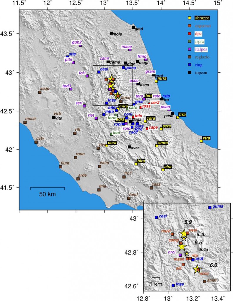
Since August 24, 2016, the central Apennines (Italy), between the towns of Amatrice and Norcia, have been struck by a huge and long seismic sequence consisting in five moderate magnitude earthquakes (5.4 <= Mw <= 6.5) and about 45000 aftershocks (http://cnt.rm.ingv.it). Details about these main events are summarized in Table 1, whereas their location as well as the aftershocks’ distribution are shown in Figure 1.
| Date | Origin Time (UTC) | Latitude (DD.dddd) | Longitude (DD.dddd) | Depth (km) | Mw |
| 2016-08-24 | 01:36:32.00 | 42.6983 | 13.2335 | 8.1 | 6.0 |
| 2016-08-24 | 02:33:28.00 | 42.7922 | 13.1507 | 8.0 | 5.4a |
| 2016-10-26 | 17:10:36.34 | 42.8802 | 13.1275 | 8.7 | 5.4b |
| 2016-10-26 | 19:18:05.85 | 42.9087 | 13.1288 | 7.5 | 5.9 |
| 2016-10-30 | 06:40:17.36 | 42.8322 | 13.1107 | 9.2 | 6.5 |
Table 1: Dates, origin time and hypocenters coordinates of the largest events (Mw ≥ 5) occurred during 2016 central Italy seismic sequence
The strongest earthquakes have been recorded by a number of high-rate sampling (from 1 s to 0.05 s) continuous Global Positioning System (HRGPS) stations belonging to several networks developed for both scientific and surveying purposes. In detail, raw phase data were obtained from the following GNSS networks or agencies: RING (INGV RING Working Group, 2016; http://ring.gm.ingv.it), Istituto Superiore per la Protezione e Ricerca Ambientale (ISPRA, http://www.isprambiente.gov.it), Dipartimento di Protezione Civile (DPC, http://www.protezionecivile.gov.it), Regione Lazio (http://gnss-regionelazio.dyndns.org), Regione Abruzzo (http://gnssnet.regione.abruzzo.it), Leica ITALPOS (http://it.smartnet-eu.com) and Topcon NETGEO (http://www.netgeo.it). The strongest earthquakes occurred in October 2016 were also recorded by five high-rate sampling (0.1 s) episodic GPS stations installed on benchmarks belonging to the INGV CaGeoNet network (Galvani et al., 2012).
During the 2016 central Italy seismic sequence, the collaboration developed between the above mentioned research institutes and agencies allows us to provide for the scientific community a freely-available data archive consisting in hourly Hatanaka-compressed rinex files for a time interval of few days before and after every main shock. This data archive is available at the following link:
ftp://gpsfree.gm.ingv.it/amatrice2016/hrgps/data/
with the following structure: yyyy/rate/net/ddd/ssssdddt.yyd.Z. In this repository, a list of all the sites available for each sampling rate is provided.
High-rate GPS time series (“GPSgrams”, ASCII files) for the main shock (Mw 6.0) occurred on 2016 August 24 [Avallone et al., 2016], carried out using both Precise Point Positioning (gd2p, Gipsy-Oasis II, Bertiger et al., 2010) and Double-Difference positioning strategies (Track, Gamit/Globk, Herring et al., 2010), are also available at the following link:
ftp://gpsfree.gm.ingv.it/amatrice2016/hrgps/solutions/20160824/
In this repository, a readme.txt file, containing information about the GPSgrams ASCII files format, is also provided.
The present report as well as the HRGPS data repository will be updated in case of further earthquakes with Mw ≥ 5 in the same area.
Figure 1: Location of the main shocks and of the largest aftershocks (Mw ≥ 5) of the 2016 central Italy seismic sequence and location of the continuous and episodic HRGPS stations.
References
INGV GPS-CNT working group; DPC-Ufficio Rischio Sismico e Vulcanico; ISPRA-Dip. Servizio Geologico d’Italia; Regione Lazio; Regione Abruzzo; Leica Geosystems s.p.a.; Netgeo s.p.a.


